A Day in Eden

Despite being open for 20 years now, it is the first time either of us has visited the Eden project and we were looking forward to our day out. It was a feat to create a botanical garden in a reclaimed china clay pit and it received a lot of publicity when it opened. I remember seeing photos of the biomes that would have looked just as at home on the moon, huge domes made of inflated plastic pillows on a steel frame.

I thought we were getting close when we spotted this growing bridge …

The road took us through a building site where a new housing estate is growing and will soon encompass Eden, then on to the parking areas which are named after fruits. Having left the car in Lime 2, we took the winding path down into the huge dip containing the gardens. When you are actually there, the size of the biomes is quite amazing, and they look as though they’ve weathered 20 years pretty well.

The surrounding gardens have given their best for this year and are looking a bit autumnal but there are still things to see, including this amazing bloom called Indian Poke, but since every part of the plant is poisonous, it’s maybe not the best choice for the garden!

The first biome contains the world’s largest indoor rainforest and the hexagonal roof provided a stunning backdrop to the tropical planting, which took us to different regions of the world.

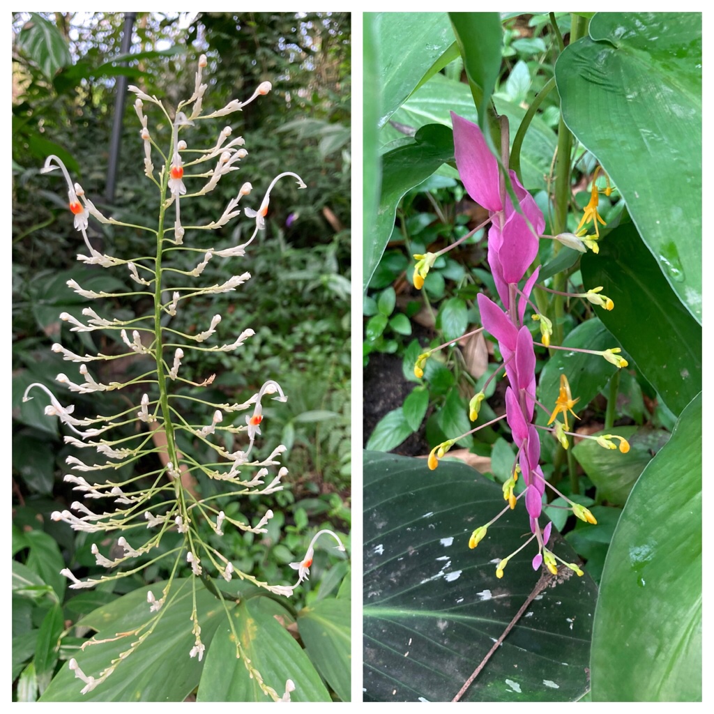
There were stunning blooms …

… and also some more discrete ones …

… a rope bridge …

… and even a love heart!

The other has a Mediterranean environment, and includes plants not just from Europe, but also South Africa, California and Australia.

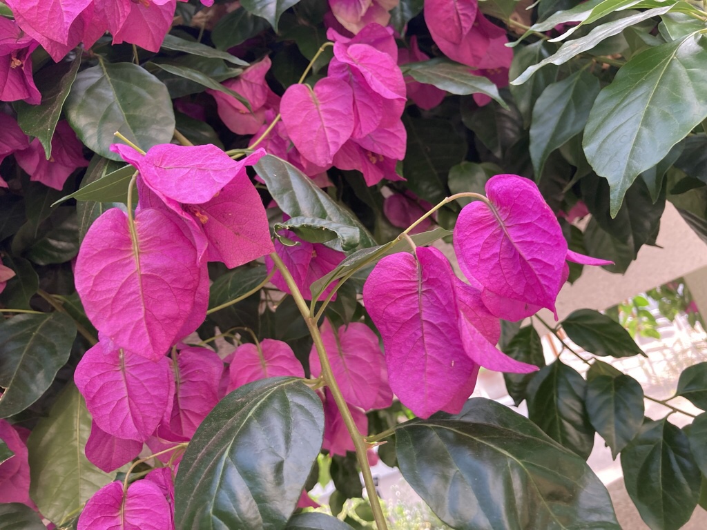
The bougainvillea was very striking …

… but my favourite of the day had to be the kangaroo paw. I’ve seen this in Australian gardens before but this display really highlighted the variety of colours … and while they look furry, they are actually quite rough!

The strong ethos of environmental awareness and education is obvious throughout the site, with lots of information about reducing our footprint, sustainability and climate change. Having said that, having finished a lunch comprising a delicious vegan salad box and pasty, the recycling system was so complicated we couldn’t identify where to dispose of our paper packaging!

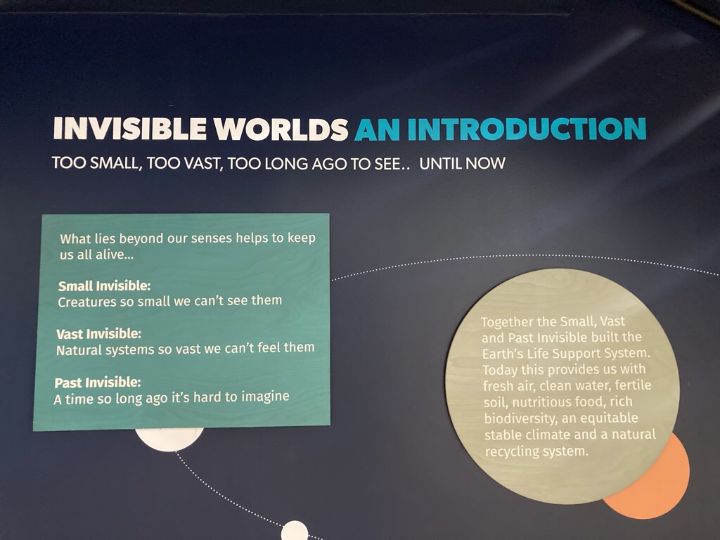
The final building is the newest, an education centre which began with this introduction …

The next room contained a huge blue grooved ceramic object with smoke rings being emitted randomly from its orifices! It represents a cyanobacterium, the first organism which was able to use sunlight to split water, making oxygen and enabling life on Earth. Another area contained a gigantic granite seed and there was a display of sustainability projects round the world but it lacked any focus and felt like a missed opportunity.

So much for an easy day wandering round a garden … we still managed to walk almost 4 miles! In the evening we had tapas at Bistro No5 …

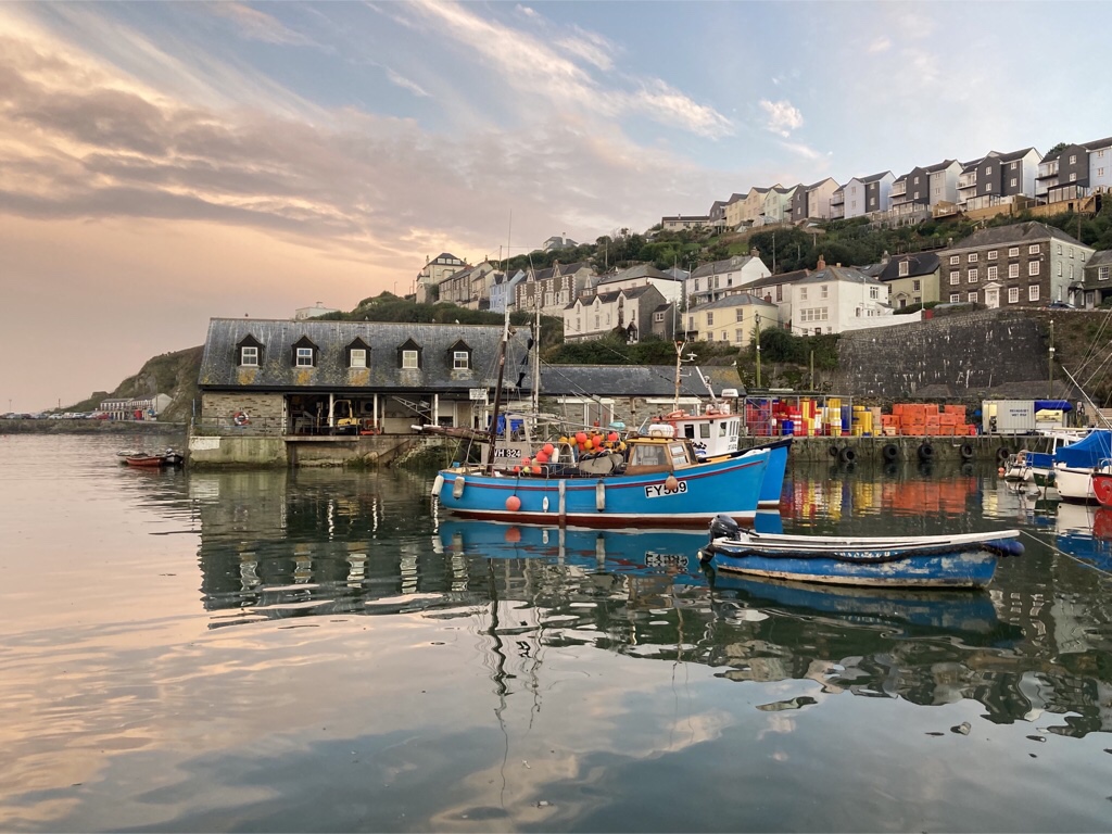
… and finished with a quick turn round the harbour before bed, where Chris took this fab shot.

Map

Gribbin Head

Another sunny day and we decided to go for a walk! Having made some sandwiches, the first challenge was to extract the car from the parking place in front of The Net Loft which required accurate reversing into a turning bay before negotiating a lane barely wider than the car. The sat nav then directed us out of Mevagissey on a different road to the one we arrived on and it seemed to take us for miles down a network of lanes before spitting us out on the B road and we resolved to be rather more wary of its directions in future. We drove back round the coast, through St Austell towards Fowey and parked in a National Trust car park at Coombe Farm so we could walk to Gribbin Head. The path took us down to a field and we had our first view of our destination.

We then took a detour towards Fowey where we could see into the harbour …

… and then to St Catherine’s Point which has had some sort of strategic fort since the Iron Age. Henry VIII built an artillery tower there and more recently, it was utilised in WWII as a firing point for the minefield set across the entrance to the harbour.

Our walk continued up to Allday’s Field, gifted to the people of Fowey in the 1950’s, and containing a number of benches to sit and admire the view. We took advantage of one for our picnic …

… before setting out in earnest for the red and white striped Daymark tower at Gribbin Head. Deceivingly, the coastal path dipped down to concealed coves twice on the way, first at Coombe Haven …

… and then at Polridmouth …

… which also had an ornamental lake and cute cottage …

… and even a small freezer with ice creams for sale, which alas was empty when we arrived!

Finally we reached the top …

… and learnt it has been a lookout since the Iron Age, the site of a beacon for the Spanish Armada, and a decoy in WWII so draw the enemy away from Fowey during D-Day. The daymark stands is 84ft high and was built in 1832 as a navigation aid to enable sailers to pinpoint Fowey harbour. William Rashleigh of Menabilly donated the land in the hope the edifice ‘would be an ornament to his grounds’ so Trinity House commissioned a ‘ handsome Greco Gothic Square Tower’ which is repainted every 7 years or so.

The other claim to fame of this spot is that Daphne du Maurier lived a short distance away at Menabilly for many years as a tenant of the Rashleighs and later at the dower house on the estate called Kilmarth where she died. She used the area as a setting for many of her books – the boathouse and shipwreck in Rebecca take place in Polridmouth, Menabilly was the inspiration for Manderley, and also features in My Cousin Rachel and The King’s General and the farmland round The Gribbin is the ovation for the avian attacks in The Birds. When she moved into Kilmarth, she found bottles containing animal embryos in the basement which led to the drug induced time travel storyline in The House on the Strand, one of her later books which I remember reading years ago.

It was time to retrace our steps to Polridmouth …

… and then take the path back through farmland to the car park. Despite being billed as a 4 mile walk, we clocked up 5.4 miles, and we felt we had done quite enough for the day so returned to The Net Loft, just venturing out later to collect our supper from the Fishermen’s Chippy!

Map

Mevagissey … pleased to meet you!

It was late afternoon when we arrived in Mevagissey. We had already glimpsed the sea, and then descended into the village which quickly became a network of narrow lanes. We fortunately located our rental easily and parked in the dedicated parking space right outside. The Net Loft is just perfect, compact but well fitted out and cosy.

We unpacked and had a cuppa then decided to have a quick walk down to the harbour as the sun set. Great idea … it was almost impossible to take a bad photo and having explored a little, we felt properly settled in as we heated up some bean stew we’d brought with us, and made ourselves quite at home over a bottle of Merlot.

Mevagissey is a working fishing port, with a tradition of boat building and was once the centre of Cornwall’s pilchard fishery. It is centred round the harbour, surrounded by a maze of narrow lanes filled with gift shops and galleries. The name comes from Meva and Issey, old Cornish for the two 6th century Irish missionaries who came to Cornwall to convert the natives to Christianity.

We woke to a lovely sunny morning and wandered down to the harbour, taking yet more photos, then walked round towards the lighthouse.

We took a path which climbed up above the village …

… and got a great view across the bay to the town of St Austell and further round to the Daymark at Gribben Head, which is our destination tomorrow.

We continued down to the cove at Portmellon where The Shack served fab coffee and we found a bench in the sun to drink it, before returning inland through West Bodrugan Wood and back over Polkirt Hill back to Megavissey.

By this time, the tide had gone out, so we had to take more pics of the harbour! We had sandwiches in a cafe, with a side of chips for Chris, before browsing the shops in the afternoon and sitting in the sun with an ice cream.

Back at the Net Loft, we made a cuppa and I returned to my holiday reading. I’d already finished The Cove by LJ Ross, the same author who wrote Scyamore Gap last trip, which was similarly a little far fetched, but still a good holiday read. Now I got stuck into Snapped in Cornwall by Jane Bolitho … which I’d noticed on a shelf yesterday and downloaded on my kindle. It is the first of a series featuring Rose Trevelyan a painter and photographer based in Cornwall who has a knack for solving murders, and she’d solved the first one by bedtime!

Map

Chris & Elaine’s Cornish Celebration 2021

Ten years ago, Chris proposed on the cliff at Tintagel and now we are returning to Cornwall for our tenth wedding anniversary. We have rented a cottage in Mevagissey, a charming fishing village on a stretch of the south coast often referred to as The Cornish Riviera, with its rolling green headlands, clear water and sandy coves. The destination was carefully chosen as our celebration always includes a boat trip and the local Fowey ferry will fit the bill perfectly.

There will be plenty to keep us busy for a week, with both the Lost Gardens of Heligan and The Eden Project on the doorstep as well as miles of coastal path to explore!

So we better get packed, ready for a change of scene, some bracing sea air and some Cornish ice cream!

Journal Entries

Mevagissey … pleased to meet you!

Gribbin Head

A Day in Eden

Dodman Point

Fog & Dolphins

Fowey’s Hall Walk

Map

Ingleton Waterfalls & Twistleton Scar

I’d seen some pictures of solitary trees growing out of the limestone pavement at Twistleton Scar and when we looked at the map, realised we could combine this with the Ingleton Waterfall Trail. The trail was opened in 1885 after paths and bridges were built to improve access to the waterfalls. Today it is well organised with a big car park and an entry fee which seemed reasonable for a 4.5 mile trail and a number of waterfalls along the way. We walked uphill along the River Twiss passing Pecca Falls, Pecca Twin Falls and Holly Bush Spout.

As we climbed out of the valley, there was a stall selling refreshments and the fresh lemonade with spring water was most welcome.

Round the corner was the singularly most impressive waterfall, Thornton Force.

The path then heads our of the valley and along Twistleton Lane, but we took a detour, along a bridle way which climbed up to the top of Twistleton Scar.

At the top we found the limestone pavement, sheep and a few trees.

We found a sheltered spot for to eat our sandwiches …

then made our descent. The trail continues along the banks of the River Doe passing Beezley Falls and Baxenghyll Gorge, but there are only so many waterfalls you can photograph! We returned through the village to the car park and were exhausted! At 7.4 miles, it wasn’t the most we’d clocked up, but with all the steps up and down and the climb up Twistleton Scar it felt the most demanding.

Back for a cuppa and to read more of my Dales mystery. I love it when I find a book set where I’m staying and several of the places mentioned are local like Goat Lane, Twistleton & Ribble so I wasn’t surprised when I googled Julia Chapman and found that while Bruncliffe is fictional, it’s location is exactly where Settle is, just two miles down the road! And that’s where we headed for dinner, to The Talbot for a very good meal on our last night, before driving home tomorrow.

Had a great drive home, stopping at Little Moreton Hall in Congleton on the way, just a short hop from the motorway. Well worth a visit with really inspiring volunteers.

Postscript

Hadrian’s Wall was a great idea for a destination and the reality certainly ticked all the boxes. We drove 1181 miles, walked 75 miles and visited three National Parks … not record breaking but great fun especially as we only had one wet day. We walked round the highest lake in England, visited the highest single drop waterfall in the country and while we might not have climbed the Yorkshire Three Peaks, we did photograph them! None of the photos do justice to the size of the landscape with huge open spaces, big skies and sheep everywhere and we will definitely be going north again.

Chris’s Photos

Chris rarely gets a photo included here as it takes time to convert raw files and he processes them in Lightroom once we get home, so click on the photo below to go to his Flickr album and he’ll add his photos over the next week or two … worth a look and a diary note!

Keld waterfall ramble....another one!😊

Keld waterfall ramble....another one!😊

Malham Tarn

I woke early and finally finished my book, leaving several loose ends which no doubt continue to the next book in the series! I’ve now gone from a body in Scyamore Gap to one in Gordale Scar where we walked yesterday in a Dales mystery called Date with Death! Sounds like this walking lark might be a bit more dangerous than just a blister!

We began our day with another of the best drives in the dales, along Goat Lane which climbs out of Stainforth then heads uphill with the 694m peak of Pen-y-Ghent appearing on the left, the lowest of Yorkshire’s Three Peaks.

The lane becomes the Pennine Way and dips down into the valley of Littondale, with the scattered cottages of Halton Gill at the foot of the fell. Despite meeting several cars, a cyclist and two walkers hiking the Pennine Way, it still feels a long way from civilisation and when you look at a map, you realise you are!

We looped round to Malham Moor and parked beside Malham Tarn, 377m above sea level and the highest lake in England, then walked round it. The whole area is owned by the National Trust, including Tarn House on the far side of the tarn, once owned by Walter Morrison who had such visitors as Charles Darwin and John Ruskin as well as Charles Kingsley who was inspired by the local scenery and Darwin’s ideas of evolution when he wrote the Water Babies.

We stopped to eat sandwiches, then continued walking round, spotting a rabbit and deer on the way!

The last stretch took us across fields to an old smelt chimney which gave a great view all round. During the 18th century, lead, copper and zinc carbonate were mined on Pike Daw, the crushed metal ore was processed at the smelt mill and a long flue led from the mill to this chimney, where the toxic fumes dispersed.

Another great walk and the sun even came out towards the end. Back to our cottage and a curry feast curtesy of the Co-op … perfect!

Map

Malham Cove

After a quick forage in Settle for a few groceries, we went walking, having passed these fine chaps on the way …

Malham Cove is apparently the most popular walk in the Yorkshire Dales and why not, when according to one story it is a giant hoof print made when the Norse god Odin was riding his horse Sleipnir! It has been attracting visitors for centuries, with painters such as JMW Turner promoting the area further. It’s a popular spot, but there was ample car parking and plenty of space for everyone. We took the footpath through the village and across the fields to Malham Cove, a huge limestone amphitheatre shaped cliff and sat on a rock and ate our sandwiches pondering the fact that this would once have been a huge waterfall. Today there is a small underground stream that emerges at its foot and becomes the Malham Beck. Above were climbers attempting ascent of the rock face.

We took the path to the left which became quite a long flight of rough steps to the top of the cliff. We could look down and see the path snaking back to the village.

The top of the cove is a large area of deeply eroded limestone pavement, where slightly acid rainwater has gradually dissolved the rock along faults and cracks.

Clints are the blocks of limestone that constitute the paving and grykes are the fissures that separate them where a varIety of plants thrive as the sheep can’t get them!

It was best to take care the gaps were quite big enough to trap a foot. If it looks familiar, it was the spot that Harry and Hermione camped out in Harry Potter and The Deathly Hallows.

From here we followed others, across the top …

… then down to Gordale, then left, alongside the stream, into another amphitheatre of cliffs either side towards a waterfall at the head of the scar.

Looking outwards, the narrowing of the scar is almost more obvious.

The final leg of the walk was back to Malham village via Janet’s Foss, a waterfall where the drop pool was traditionally used for sheep dipping. The name Janet or sometimes Jennet is thought to be a folk tale reference to a fairy queen who inhabited a cave at the rear of the waterfall.

As we walked back to the car, we’d clocked up 6.8 miles and the completion of the most popular walk in the Yorkshire Dales. We had a quick look in the shop and I was making a note of a novel set in the Dales for future reading when I overheard a walker who had misunderstood the bus timetable. He had a problem getting back to Settle for his train, and without thinking too much about it, we offered him a lift and were happy to help.

That evening we cooked … or leastways heated pasta sauce we’d bought at Tebay services to have with pasta and broccoli … once we’d mastered the hob!

Map

Keld Waterfalls

Apart from a brief pause at the Dandry Mire Viaduct at Garsdale …

… our first stop was Hardraw Falls, famed for being the highest single drop waterfall in England at 100ft. As we saw from the poster in the tea room, it’s been an attraction since Victorian times, but today was somewhat quieter with a choice of path either to the base or the top of the falls. We chose the easy path with the best view of the falls …

… then walked back for coffee and a scone with cream and jam to keep us going.

Buttertubs Pass is a 6 mile stretch of road between Simonstone in Wensleydale and Thwaite in Swaledale and has been described as a spectacular road. We enjoyed it … both ways as it happens … one way more slowly with a couple of stops and then back, faster in search of a late lunch!

There are lots of these small banty barns or cow houses which protest the animals in winter. They are stabled below and the hay is stored above, cut from the surrounding fields. In the spring they are let out to graze and the muck used to fertilise the fields.

In between, we went walking in Keld, in search of waterfalls, but while ten fine days has made our trip north a real pleasure, it hasn’t boded well for the flow of water in the falls. We walked along the River Swale …

.. but the walk instructions were a bit vague, so we only found East Gill force …

… and Wain Wath Falls where people were actually swimming … albeit in wet suits … while Kidson Falls eluded us.

Some of the countryside was lovely and here’s one of those banty barns up close.

Having worked up an appetite, we just made the Wensleydale Creamery in time to experience their Yorkshire Wensleydale & Yorkshire Red Cheese on Toast served with Tomato & Chilli Chutney and Dressed Leaves and a cup of Yorkshire tea … as Wallace would say … cracking!

A couple more pics along the way – Whernside, the highest of Yorkshire’s Three Peaks at 736m, rises behind the Ribble Viaduct, the longest of 22 viaducts along the 73 mile Settle to Carlisle railway …

… and Ingleborough the second highest peak and the most recognised, looking like a chunk’s been chipped off!

We found our rental, a cute stone cottage in Long Preston …

… and had a quiet evening, not even needing dinner after such a late lunch, just a snack.

Map

Blelham Tarn

I was reading about Ballie Scott this morning and discovered that John Ruskin had spent the last 18 years of his life living in Brantwood on Coniston and the house is open to the public so we went for a look. While the social criticism of John Ruskin and his romantic idealization of craftsmen taking pride in their handiwork inspired the Arts & Crafts movement, we were surprised that his home looked quite Victorian, a bit dark and cluttered with collections of all sorts of things like coins and geology samples. Nonetheless, the visit was interesting and the view across Coniston was lovely and I can see why he fell in love with the location.

Next stop was Wray Castle, a Victorian neo-gothic house built for a retired Liverpool surgeon in 1840. It’s been owned by the National Trust since 1929 and is just a shell, but has a convenient car park so we could do a circular walk.

Firstly we took the path in a loop down to the shores of Windermere and past a waterside barn …

… then back up the hill and round Blelham Tarn …

…with views towards Ambleside and Wansfell behind …

…before returning through this pinch stile to the car. It was a lovely afternoon and the short walk was perfect.

On the way back, we drove through Ambleside and Windermere which were heaving with visitors and were pleased we’d managed to avoid the crowds on a busy Bank Holiday Sunday, but still have a fab day out. We have only had a glimpse of the Lake District and even Kendal looked as though it deserved a better look, but time was short.

We ended the day munching pizza while watching the first of a new series of Vera and prepared to pack up and head to Yorkshire in the morning

Map

Blackwell

Next day, the sunlight was streaming into the apartment as we got ready for a real treat. I was so looking forward to visiting Blackwell, an Arts & Crafts house, designed by Mackay Hugh Baillie Scott (1865-1945) and by far the best example of his work open to the public.

Before we started exploring, we had coffee on the terrace in the sunshine, overlooking Lake Windermere and this set the tone of the day … decidedly chilled … a brew with a view!

Blackwell was built as holiday for Sir Edward Holt, a wealthy Manchester brewer and completed in 1900, and was later a school and offices but has survived with almost all its original decorative features intact and has been open to the public since 2001. The furniture and objects in the rooms are not original to the house but are by leading Arts and Crafts designers and most are contemporary to the house.

Blackwell is asymmetrical in design with local influences such as the tall round chimneys and the use of local slate and sandstone. A variety of crafts have been incorporated into the house including tiles in the fireplaces, carved stone and wood paneling, stained glass, wrought iron and lead work, wall coverings and beautiful plaster work.

Blackwell gave Baillie Scott the chance to put his ideas on the use of space, light and texture into practice on a grand scale and as it didn’t need to be quite so practical as a main home, there was more scope to experiment. The main hall shows influence from old baronial halls, but is also modern, with plenty of room for the billiard table which would have stood under the six copper lights and the piano for musical evenings. There are also places to retreat such as into the minstrel gallery or by the fire with a book. At first glance, the peacock frieze appeared to be mosaic, but looking closer, it is wallpaper which took nine months work to conserve but looks amazing.

The dining room was cosier, but there is still good colour in the hessian wall covering and the fireplace is a joy.

The White Drawing Room comes as a surprise after the first two rooms, and immediately brought to mind Rennie Mackintosh’s House for an Art Lover in Glasgow. Firstly there is the amazing panorama from the window opposite the door …

… the dazzling white gesso everywhere … the ceiling panels, wall freeze and also the capitals which look like delicate trees …

… then another great fireplace with original firedogs and the vivid blue of the tiling complements the blue in the stained glass windows.

The Rowan tree appears in the family crest and is used as a motif throughout the reception rooms …

More stained glass and tiling details … so pretty!

After checking out the exhibition about the Arts & Crafts movement and another celebrating cultural connections with Japan at that time, we settled in the garden for lunch … I said it was a chilled day!

On the way back, we stopped at Sizergh (pronounced sizer to rhyme with Tizer!). The core of the castle is a 14th-century pele tower and hall and there have been additions every century since but we didn’t go inside as it was such a lovely day. Instead we just wandered round the gardens and even the estate walk seemed too much like hard work.

As we left we saw a sign for a farmshop and we picked up some Lancashire cheese made on the farm and cake. They also had a milk vending machine, selling whole organic milk from cows we saw being milked … and we confirm it was lovely for porridge and muesli.

In the evening we walked to Corner 134 in Kendal where we had a lovely dinner. We started with a platter of mixed tapas style mouthfuls, followed by venison with mustard & raspberry sauce for me and a veggie filo tart with taleggio for Chris. Afterwards we had vanilla ice cream with Pedro Ximenez. Who’d have thought ice cream with sherry poured over it was a thing … I’m obviously behind the times as Rick Stein did this 10 years ago!

Map